 |
 |
 |
 |
0201130245G8I04.tiff 12-Jan-02 22:27 300k
|
|
|
|
Date: 1/14/02 6:43:35 PM Pacific Standard Time
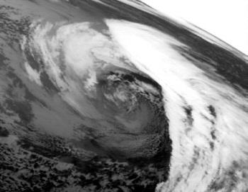
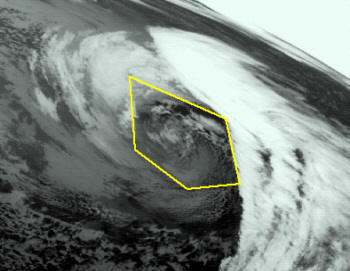
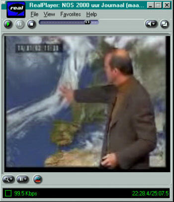
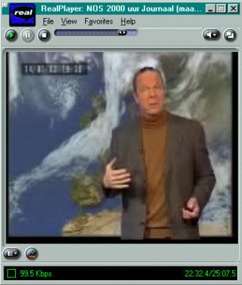
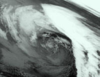
This strange weather pattern over the Atlantic Ocean and Western Europe lasted for at least 9 hours (see time on screencaps). See this broadcast from today's dutch evening news, weather starts at 22min into the broadcast.
http://cgi.omroep.nl/cgi-bin/play?/tv/nos/journaal/maandag.2000.rm
I made 3 screencaps, showing the cloud formation over time.
Dutch TV-Text devoted its weather page to jetstreams today, possibly attempting to explain this phenomenon.
http://teletekst.nos.nl/cgi-bin/tt/nos/page/m/717-1 (images)
http://teletekst.nos.nl/cgi-bin/tt/nos/page/t/m/717-1 (text)
Here is my translation [my comments in square brackets]:
Page 1:
A very strong wind is usually seen at a height of 9 to 10 kilometers [6 miles], this is called a jetstream.
Weather specialists call events like this a jetstream when this type of wind has an average speed of more than 100 km/h [60mph] (11 Bofor of more). Frequently, higher speeds are measured, sometimes of more than 350 km/h [220 mph].
The jetstream usually has a length of thousands of kilometres, a width of a few hundred kilometers, but is only a few kilometers high.
Page 2:
So, it's a stretched narrow band with high speeds, that slides through our atmosphere curved like a river [huh? with speeds of up to 220mph?].
Usually the band is directed from West to East, but in some spots its direction can be northward or southward because of its curves.
Jetstreams are not unique to our area, but can also be seen around the equator or near the polar circle.
Page 3:
Scattered across the globe, several jetstreams can occur at the same time, also known as polar or arctic jetstreams [What? Sounds like BS to me].
The direction and location of the jetstream is of high importance for our weather. When from the North a jetstream will usually bring colder temperatures than when from the West or South [duh!].
The jetstream will also function as a conduit for weather depressions.
Page 4:
Somtimes, you can recognize the jetstream from cloud patterns [let me guess? such as today, I'm sure :)] A characteristic will be the very long bands of high clouds [ah, I see!], often in the form of "windfeathers" [unfamiliar with the term].
These patterns usually predict fast changes in our weather.
When the jetstream is close to or over our country, we usually get deveral depressions with a lot of rainfall and winds [a cover of fog is over Amsterdam all day today and tonight].
Date: 1/16/02 10:46:59 AM Pacific Standard Time
After mailing you, I looked at time-lapse images from MeteoSAT (requires Netscape):
http://www.nottingham.ac.uk/meteosat/satshow.html
Individual images can be downloaded from:
ftp://ftp.nottingham.ac.uk/pub/sat-images/cycles/D2M/
All D2 satellite pictures are archived here: http://satpix.nottingham.ac.uk/satpix/archive/D2/
Date: 1/15/02 6:10:39 PM Pacific Standard Time
Hey kent, was watching the animation of the dutch pentagram on that news link, and i couldnt help but be amazed at the fact that it seemed to rotate with the clouds. For some odd reason, i kept thinking about this old cartoon i used to watch, called Robotech, where they had this device called the pinpoint barrier system, that protected this spaceship from damage and enemy fire. The think about them is that they were mobile, and something in that animation brought that to me. Here is my thought: What if it is a mobile shield like the aforementioned things? What if some of those radar images you have shown, of things striking a shield were ground based shields, and someone has perfected a mobile one? I ask this because there are alot of towers and things going up EVERYWHERE, and I work for Voicestream Wireless, and where those towers are, noone has service, not digital or anaolg providers, in some instances, so what the 'ell are they? And secondly, I noticed from links, specifically that new 1998 archive link, about how storm systems seem to accompany this whole issue. I dunno, I wish there was someway to investigate further, but alas, I am at a brick wall. Well lemme know what you think!
EDITOR: the pentagram interests me because of it's connection to the Golden ratio, the constant, Phi. If some kind of a shield were to be made, a wave-form generator expressing Phi might do it. Also somewhere within that Pentagram lie the Azores rumored to be the northern reach of Atlantis. Been hearing that things are moving underwater, maybe a pyramid lurking in the Deeps there.
PENTAGRAM |
Date: 8/11/01 9:35:26 AM Pacific Daylight Time
My people have been on this for 5 months. The higher path website is on the level in all respects: the outer Islands of Atlantis ran from Mexico, through and around Cuba to the Azores.The main Island where Poseidia was located is between Hispaniola and Cuba. The bulk of The Bermuda Triangle is an inter-dimensional Vortex. The Gov't has known since the 70s and are attempting to exploit it. All of this is real and about to re-surface in every way. |