

 |
 |
 |
Date: 1/26/02 5:41:01 AM Pacific Standard Time
Kent,
Here's a lead (I think). Began to wonder if GPS isn't the new cover for GWEN -- I mean, who can argue with global positioning? After months of hunting radar rings I certainly see a correspondence of generation with these GPS/GWEN sites. I'm a novice on waves [bf emphasis mine] & scalar, but when they talk about "impedence" [below] I definitely hear "scalar."
Does it really matter what we call it? All these wave towers can't be good for brains, and they are still referring to them as "ground waves."
I'm sure you have resources more up on this subject than I am who might find some interesting reading here. Just a thought.
I'm attaching another paper from the ITS site about how GWEN became GPS that I copied off for further perusal.
Institute for Telecommunications Science (Dept. of Commerc)
Below, some articles on the subject -- found at:
http://www.its.bldrdoc.gov/tpr/2000/outputs00/journal00.html
Augmented Global Positioning System
Outputs
 |
|
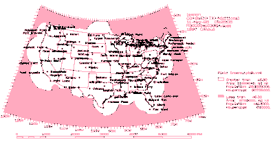
Figure 1. Signal coverage prediction plot showing nationwide coverage of the planned nDGPS service. (CLICK image to enlarge.) |
 |
|
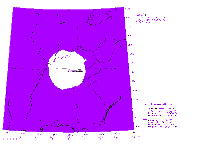
Figure 2. Signal coverage prediction plot for the DGPS reference station at Hartsville, TN. (CLICK image to enlarge.) |
ITS Outputs in FY 2000
Journal Articles
A.U. Bhobe, C.L. Holloway, M. Piket-May, and R. Hall, "Coplanar waveguide fed wideband slot antenna," Electronics Letters, vol. 36, no. 16, pp. 1340-1342, Aug. 2000.
A new design for a coplanar waveguide (CPW) fed slot antenna is presented. The impedance matching and the radiation characteristics of this structure were studied using the method of moment technique. This antenna has an impedance bandwidth (for a VSWR < 2) of 49% and a radiation bandwidth of 42% about its 4.8 GHz center frequency, compared to the 12-20% impedance bandwidth of the standard CPW fed slot antenna. The cross-polarization in both the principle planes is at least 20 dB below co-polarization across the entire bandwidth. Simulated and measured results of the antenna are presented. This wideband antenna has significant applications in wireless technologies.
N. DeMinco, "Propagation prediction techniques and antenna modeling (150 to 1705 kHz) for Intelligent Transportation Systems (ITS) broadcast applications,"IEEE Antennas and Propagation Magazine, vol. 42, no. 4, pp. 9-34, Aug. 2000.
This paper discusses the basic aspects of radio-wave propagation and antenna modeling in the band of frequencies from 150 to 1705 kHz. The paper contains descriptions of both sky-wave and ground-wave propagation-prediction models, in addition to the methodology used to analyze antennas that operate in this band. A method of calculating and normalizing antenna gain for systems computations is also discussed. The sky-wave models described in this paper are valid from 150 to 1705 kHz. The ground-wave models described in this paper are valid from 10 kHz to 30 MHz. The propagation of radio waves in the band of frequencies from 150 to 1705 kHz includes both a ground wave and a sky wave, and is quite different from propagation at any other frequency. The methods used for antenna modeling and analysis in this band are also quite unlike those in other bands. The AM broadcast band of 535 to 1605 kHz is planned to be used in the Advanced Traveler Information Systems (ATIS) of Intelligent Transportation Systems (ITS), to provide information such as road conditions, road hazards, weather, and incident reporting for rural travelers. The band of frequencies from 285 to 325 kHz is presently being used in another application of ITS, called the Differential Global Positioning System (DGPS), which will be used for precision location systems and making performance predictions for both of these ITS applications, or for any other systems that operate in this band of frequencies from 150 to 1705 kHz. Some examples of comparisons of measured and predicted data are also contained in this paper. A computer program that includes all of these propagation-prediction models and antenna-modeling techniques was used to generate these examples.
C.L. Holloway, "Expressions for the conductor loss of strip-line and coplanar-strip (CPS) structures," Microwave and Optical Technology Letters, vol. 25, no. 3, pp. 162-168, May 2000.
In this paper, we present closed-form expressions for the attenuation constant due to conductor loss for strip-line and coplanar-strip (CPS) structures. These expressions are functions of a universal parameter referred to as the stopping distance, where it is shown that this stopping distance is a function only of the local edge geometry, i.e., the strip thickness, the shape of the edge, and the material of the strip conductor. We also present an expression for the current distribution of the ground planes of a strip-line structure, which is used to derive an expression for the conductor loss of the ground planes. Results obtained with these loss expressions are compared to, and closely agree with, both experimental results and full-numerical results found in the literature for these two structures.
C.L. Holloway and E.F. Kuester, "Equivalent boundary conditions for a perfectly conducting periodic surface with a cover layer," Radio Science, vol. 35, no. 3, pp. 661-681, May-June 2000.
Using the method of homogenization, effective electromagnetic properties for a two-dimensional, perfectly conducting, periodic rough surface with a thin periodic cover layer are derived. This allows for the development of an equivalent boundary condition for the "effective" fields at such a surface. It is shown that the coefficients in this equivalent boundary condition can be interpreted as electric and magnetic polarizability densities. We apply this boundary condition to calculate the reflection coefficient of H- and E-polarized plane waves incident at a rough, perfectly conducting surface. The reflection coefficients derived here are compared with previous results from the literature for surfaces with no cover layer, demonstrating the accuracy of the new equivalent boundary condition. We also obtain previously known equivalent boundary conditions for a flat perfectly conducting plane with a thin cover layer as a special case of our result. This work is a first step in the derivation of generalized impedance-type boundary conditions for conducting rough interfaces (to be published separately).
The NAVSTAR global positioning system (GPS) is a space-based radionavigation system that consists of a constellation of 24 satellites in 6 orbital planes. GPS provides accurate three-dimensional position, velocity, and precise time to users worldwide, 24 hours per day. GPS was originally developed as a military force enhancement system. Although still used in this capacity, GPS also provides significant benefits to the civilian community. To make GPS service available to the greatest number of users while ensuring that national security interests are protected, two GPS services are provided. The precise positioning service (PPS) provides full system accuracy to military users. The standard positioning service (SPS) is available for civilian use but has less accurate positioning capability than PPS, approximately 100 meters. Because the SPS accuracy of 100 m does not meet most civilian navigation and positioning requirements, various augmentations to GPS are used to provide higher accuracy positioning, as well as increased integrity and availability of the positioning information. One form of augmentation, differential GPS (DGPS), can provide 1- to 10-m accuracy for dynamic applications and better than 1-m for static users. In a 1994 report, the result of a study done for the Department of Transportation, ITS recommended implementation of a radio beacon system, operating in the 300-kHz band, modeled after the U.S. Coast Guard's (USCG) local area DGPS. This system would provide nationwide coverage of DGPS for surface applications (DeBolt et al., 1994; see Publications Cited).
For the past four years ITS researchers have been conducting a study, sponsored by the Federal Highway Administration, to determine the optimum location and operating parameters of the DGPS reference stations required to provide this civil navigation and positioning service to all surface users across the nation. This new service will be known as the nationwide differential global positioning system (nDGPS). The use of this service will have an enormous impact on a diverse set of activities, including ocean and land transportation, surveying and mapping, farming, waterway dredging, recreation, emergency location and rescue operations, and many others that have not yet been identified.
The foundation of nDGPS is the DGPS reference stations currently operating or planned by the USCG and the U.S. Army Corps of Engineers; this system provides coverage of the radiobeacon DGPS signal for coastal areas, harbors, and inland waterways. ITS added additional DGPS reference stations to this foundation to provide nationwide coverage of the DGPS signal. To achieve this additional signal coverage, ITS used the Ground Wave Emergency Network (GWEN) sites, owned by the U.S. Air Force Air Combat Command. The GWEN system is an existing Federal Government asset that provides a cost-effective method of implementing nationwide coverage of the DGPS signal. The GWEN sites were used at existing locations or moved to new locations as required to complete the nDGPS signal coverage. Figure 1 shows a signal coverage prediction plot of this nationwide coverage. Installation of the GWEN DGPS reference stations is currently underway.
In FY 2000, ITS has provided technical support to the Department of Transportation that has been required for the implementation of the nDGPS. Much of this support has been in the form of interference analyses required to assess the impact of newly installed DGPS reference stations on existing aviation beacons in the 300-kHz frequency band. These analyses are particularly important for those stations whose transmitter powers have been increased from the recommended levels to provide signal coverage in unanticipated coverage gaps. A signal coverage prediction plot for one such station, at Hartsville, TN, is shown in Figure 2.
For more information, contact:
Dr. John J. Lemmon
Phone, email withheld
EDITOR: HARTSVILLE, TN rings a bell
UPDATE: U.S. Air Force Linked to Electronic Warfare Attack in Tennessee HARTSVILLE, TENN - Newly released documentary and eyewitness evidence now links an apparent July 6, 2001 electronic warfare attack on a radio station and weekly newspaper in Hartsville, Tennessee to a nearby unacknowledged secret access project (USAP). This secret project, eyewitnesses say, includes the U.S. Air Force as paymaster, U.S. government aircraft as transportation and security craft; military troops in black uniforms; and black unmarked triangular aircraft. The project may also include a secret electronic warfare unit capable of disabling nearby media outlets with destructive electromagnetic energy.
Date: 1/26/02 9:54:07 AM Pacific Standard Time
SHERLOCK BILL
Kent, you didn't seem to include these links when you mentioned Hartsville, TN and those DGPS sites. It helps a lot to know right where all the antennas are, right?
The Trasmission Frequency for DGPS stations ranges from 286-325 KHz, just so you know.
DGPS sites: Hartsville, TN, etc. All data on each location! Woo!
http://www.nis-mirror.com/systems/dgps/DgpsCompleteConfiguration.htm
DGPS Current Status:
http://www.nis-mirror.com/systems/dgps/DgpsCurrentStatus.htm
Here's the main site containing the above 2 links:
http://www.nis-mirror.com/systems/dgps/
Same DGPS config info as the first link above, comma-delimited:
http://www.gpsinformation.net/dgpsconfig.txt
The dgpsconfig.zip is the HTML table version of the last link. You'll like that, because that last link breaks up the lines of data.
ALL THE GPS LINKS you'll probably ever need are here!
World DGPS RadioBeacon list - November 2001:
http://www.csiwireless.ca/support/pdfs/radiolistings.pdf
THERE'S the List with a capital L, Kent. There planet's FULL of these KHz-transmitting DGPS stations!
I wasn't able to neatly convert that PDF file. It looks neat in Acrobat, though! I think we can count on CSI Wireless to gather the stations like this from time to time.
EFFECT OF NON-HERTZIAN SCALAR WAVES ON THE IMMUNE SYSTEM
Ologoderoglioma related to occupation as a welder Then as I was going through a book on "welding safety" published by Lincoln Electric (Arc Welding Safety)E205, I was shocked to find a supplement to the required warning placards, that was only required in California, (supplement #65) it mentions EMF as a possible health hazard, and makes recommendations for procedures to minimize exposure.