Please use Netscape or IE 4.0, forget aol
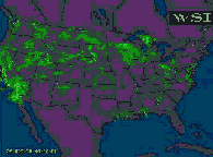
25-MAR-98 21:00 ET ................................ 25-MAR-98 22:00 ET .............................. 25-MAR-98 23:00 ET ...
Progressive animation
|
|
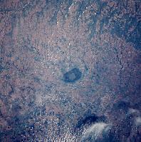
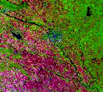
| 5. STS040-80-062 This photograph of the Great Bend area was taken June 11, 1991. Thefeature in the center of the photo is Cheyenne Bottoms, a 41,000-acre natural basin located about 7 miles north of Great Bend. | Landsat Image of vortex area, near Hutchinson, KansasKnown as the Salt City because of the vast salt deposits beneath it , Hutchinson is known for its active salt mines. The area's mines produce table, agricultural and road quality salt, which is shipped throughout North America.
|
Witchita, Kansas, biggest employers
Boeing Company; McConnell Air Force Base; Cessna Aircraft Company; Learjet Inc.; Raytheon Aircraft Co.
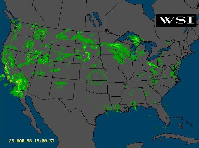
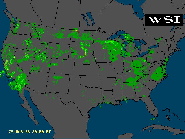
All over the U.S. there were red alerts for bad to severe storms on 3/25/98
Well, that isn't so unusual, but after looking at the radar screen for 3 years I have never seen perfect circles of rain before. Last night there was a circular pattern in the mid west section of the U.S. I found that so unusual, and for a long time it never changed, and finally after a few hours it just disappeared.
Today looking at the radar there is another perfect circle on the radar screen. It is located in the mid west also. I have never seen anything like this before......
We have observed these rings on several occasions but with a different pattern. The formed very similar circles for a relatively short time and faded. They did not travel with the weather flow. The most interesting point is that we have seen as many as 5 circles at one time. They were equal distant apart. Each one was slightly lighter than the first. None had rain in the center but were clear with no other weather around them. On three occasions the strongest started in the southwest and stepped across the country in a north easterly direction.
Starting in NM or CO and stepping to Iowa or SD.
Scaler waves can bounce across the country like that. They could also cause power lines to arc where the came down. We heard of no outages.
The K-index derived, at the U.S. Air Force Space Forecast Center, using data from ground-based magnetometers showed a mark jump about this same time. View charts at. http://www.sel.noaa.gov/today.html
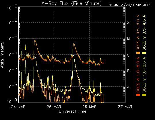
The X-ray Flux plot also showed a very high an unusual spike at this same time. The interesting thing is there was an almost a mirror spike on the 24th at the same time of day. The sun does not punch clocks like government workers do. ekklesia
Dear "Observer",
I caught your communication re weather radar circles in mid USA.
Thought you might like to read my original Nexus Magazine "Bright Skies Part 5 article - pre editing by Nexus to fit available space. I'm adding parts 1-6 also for your interest .........
We have observed perfectly circular "ring clouds" form up off of our WA coast about this time of year every year for past three years. These have diameters of about 30 km and consist of tubelar cross section clouds in annular ring forms - say five inside each other (like a Russian Doll), with three ring nests touching at outer edges covering an arc of some 90km. Outside of these rings heavy weather forms up then rushes on land giving power failures along the Darling escarpment = presumeably of overvoltage due to scalar EM wave build up in the front as it rushes in-land.
Recently we in Western Australia have had four electrical generators burnout in Collie and Kwinnana powerstations (seperated by 100km !) at the same time,leading to power failures along the west coast. These were similar but smaller scale to the big Brisbane and Auckland New Zealand power failures that burnt out four seperate power station's generators across Queensland and cut AuclandN.Z. Cities entire power - still not fully restored after one month.
In light of the Malaysian publicity on their hiring Russian company with satellite technology to create Hurricanes to blow smoke away from Borneo Forrest fires one is tempted to suggest that remarkable changes in W.A.'s rain fall over past five years that have flooded interior "semi-desert areas are due to weather engineering experiments directed at greening our desert areas. Either that or some aliens are playing around?
Best Regards,