EDITOR: now we need to wait for delayed
effects,
the
bacteria
UPDATE:
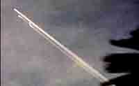
Mir set to re-enter Friday
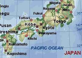
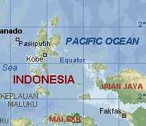
Kent: The bible code for Mir has the name Kobe
as an intersect. Is there any possibility that it could strike either of
the two Kobes on these two maps?
I ruled out the others I found because of
there northern hemispheric locations. This is interesting in light of White
Feathers prophecy."You will hear of a
dwelling-place in the heavens, above the earth, that shall fall with a great
crash"
Cal "spinner" Bright
Editor Dark Matters
News
 ALERT: Nikolai Anfimov,
the head of the Central Institute of Machine-Building, the leading expert
body for the Russian space program, acknowledged Monday that there was an
outside chance that the engines won't supply as much thrust as they are supposed
to. That could mean the station's wreckage might overshoot the dump zone.
ALERT: Nikolai Anfimov,
the head of the Central Institute of Machine-Building, the leading expert
body for the Russian space program, acknowledged Monday that there was an
outside chance that the engines won't supply as much thrust as they are supposed
to. That could mean the station's wreckage might overshoot the dump zone.
``If an engine impulse is insufficient, the station will fly farther and
the southern tip of South America could be affected,'' he told reporters.
Date: 3/18/01 8:33:40 PM Pacific Daylight Time
Hi! Found a great site for Earth grid info:
http://home.att.net/~john.aona/
The site explains red/blue junctions, where: red is marked +, and blue
is marked -.Red energy flows S to N, and W to E. Strangely enough the red
grid-vortex idea is mentioned here:
http://www.ambilac.com/part_xi.html
Notice that grid point 39 is 45:22'18.38"S by 140:27'25.75"W, &
it's a red junction (marked with a plus). Mir splash down point is 47S by
140W, a difference of 115 miles! We might as well say Mir will crash down
right over point 39! Russians are smart: they know about this earth grid
stuff. So why did they pick a spot on the earth grid where two red lines
meet to crash Mir?
Date: 3/19/01 6:58:55 AM Pacific Daylight Time
Look at the UTC time
on the MIR gif on Orbit webpage:
has 22 MAR 2001 04:44:40 UTC
This caught my eye as in the book "The Messengers" the time 4:44 was used
over and over by the Angels in their communications with the author of the
book. It may also be that either the MIR or the ISS spacestation are
connected to the HOPI Indian prophecy about when the "House in the Sky" falls.
Japan
warns about falling Mir debris
Govt to issue
warning if Mir engine fails
Effort
to warn fishing boats in path of Mir debris
March 15 7:44 PM SGT
Mir to splash down March 22
MOSCOW (AFP) - The Russian space station Mir will fall to earth "early
in the morning" on March 22, Russian space officials said Thursday. It was
the first time such a precise indication of timing had been given for the
landing of the platform, whose destruction was announced last year.
Date: 3/7/01 7:47:15 AM Pacific Standard Time
Just noticed something: At earthchangestv.com, Mitch gives 47S by 140W
for the MIR splashdown coordinates. If I'm doing this right, that Lake Vostok
is around 79S by 110E. If you go
here:
http://www.indo.com/cgi-bin/dist and put in the two coordinates, you
get
this
map with a distance of about 3300 miles. Still I hope they don't upset
any of our land masses. I was just wondering if they were planning to splash
down MIR right over Lake Vostok! That would be a kick, eh?
Mir Reentry
Description