.

.

.

.

.

.

.

.

.

.

..

Netscape 800x600

JUNE 9, 1998, BIG MAMA AWAKES

The Long Valley Caldera was formed some 700,000 years ago by an eruption

600 times the size of the one at Mount St. Helens.

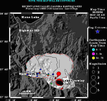
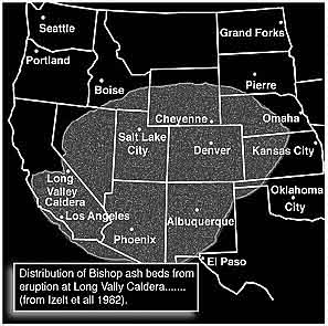
MAG DATE LOCAL-TIME LAT LON DEPTH LOCATION

3.1 98/06/21 17:47:02 37.57N 118.77W 7.0 5 mi W of TOMS PLACE

4.0 98/06/21 08:32:50 37.57N 118.78W 5.3 5 mi W of TOMS PLACE

3.4 98/06/17 21:57:47 37.58N 118.78W 6.0 5 mi W  of TOMS PLACE

3.1 98/06/15 10:41:36 37.59N 118.82W 7.2 8 mi WNW of TOMS PLACE

2.6 98/06/14 08:46:33 37.59N 118.80W 8.4 7 mi WNW of TOMS PLACE

3.0 98/06/13 21:20:28 37.58N 118.79W 7.9 6 mi WNW of TOMS PLACE

3.2 98/06/11 09:56:03 37.59N 118.80W 8.1 7 mi WNW of TOMS PLACE

3.2 98/06/10 23:40:21 37.59N 118.78W 5.5 6 mi WNW of TOMS PLACE

4.3 98/06/10 23:33:29 37.58N 118.78W 8.2 6 mi WNW of TOMS PLACE

3.0 98/06/10 08:02:16 37.59N 118.79W 6.5 6 mi WNW of TOMS PLACE

3.9 98/06/09 06:30:09 37.59N 118.80W 5.7 7 mi WNW of TOMS PLACE

3.0 98/06/09 06:24:37 37.58N 118.79W 5.4 6 mi WNW of TOMS PLACE

3.8 98/06/09 01:45:44 37.59N 118.78W 0.0 6 mi WNW of TOMS PLACE

3.0 98/06/09 01:29:34 37.59N 118.79W 7.5 6 mi WNW of TOMS PLACE

3.3 98/06/08 22:27:30 37.64N 118.80W 21.8 8 mi NW of TOMS PLACE

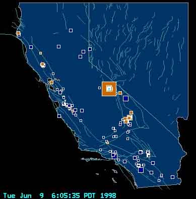
5.1 98/06/08 22:24:40 37.59N 118.79W 6.6 7 mi WNW of TOMS PLACE

4.0 98/06/07 20:55:14 37.59N 118.80W 6.8 7 mi WNW of TOMS PLACE

  EARTHQUAKE ANIMATION & DATA SITE

CURRENT USGS MAMMOTH QUAKES

LVO: Long Valley Observatory

PREHISTORIC ERUPTION

 EARTHQUAKE INDEX

 SEISMOGRAM

 larger updated ongoing event animation

  CNN: Magnitude 5.1 quake jolts eastern California

Mammoth Lakes Swarm Continuing

The earthquake swarm at Mammoth Lakes [Long Valley Caldera] that kicked off with the 5.1 earthquake overnight is still going strong late this morning. Since that original quake, there have been over 200 tremors reported... five of which were 3+. This is by far the greatest activity observed in the Caldera region so far in 1998.

For those who are not familiar with it, Mammoth Lakes also known as Long Valley Caldera... is a large volcanic caldera [collapsed cone] along the California-Nevada border region. It has not erupted in 500 years, but geologists have constructed a map based on sedimentary rock samples that shows that one eruption long ago was massive enough to have covered the western third of the United States in volcanic ash. I have a copy of this map if anyone would like to receive it via email.

In the few years that I have been monitoring it's activity, it has produced large swarms before, but the magnitude of the first quake of this swarm [5.1] and the volume per hour of subsequent tremors makes this one of the greatest swarms in recent years. Swarms are often, though ~certainly~ not always, indicators of an oncoming eruption.

New Millennium

EDITOR'S NOTE:  Having once lived in the Central Valley, CA, I have long noticed that Mammoth activity seems to send quakes along the fault lines into the Coalinga-Gilroy-Santa Cruz areas perhaps setting off the San Andreas Fault. Here is a recent Cal quake map:

DATE-(UTC)-TIME LAT LON DEP MAG Q COMMENTS

98/06/15 01:59:22 37.04N 121.48W 8.6 4.0Ml CENTRAL CALIFORNIA

ANCIENT ERUPTION

.

Gordon-Michael Scallion

more maps and ordering info

ART BELL

Transcript