SEA MYSTERIES |
.
.
.
.
.
.
.
.
.
.
YONAGUNI EXPEDITION '98LINKS DATED: TRY INTERNET ARCHIVE OR
|
SEA MYSTERIES |
.
.
.
.
.
.
.
.
.
.
YONAGUNI EXPEDITION '98LINKS DATED: TRY INTERNET ARCHIVE OR
|
TECHNOLOGY VERSUS MAGIC IN NEW GUINEAQUESTIONS, RESPONSES, MORE QUESTIONSEDITOR'S NOTE: During the devastating PNP tsunami and ongoing a team from the National Science Foundation has been drilling test holes in the fault lines, 180: Woodlark Basin Project. Below we consider the implications. THE DIARY:A journalist arrives at the drilling site. Expressing questions and uncertainties about the ongoing project, the quake, the tidal wave, he discovers a strange play between the forces of technology and the forces of magic, the legend of a serpent, a mysterious eel that thrashes its tail in anger.
|
|
The primary objectives at these sites are (1) to characterize the composition and in situ properties (stress, permeability, temperature, pressure, physical properties, and fluid pressure) of an active low-angle normal fault zone to understand how such faults slip |
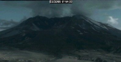
The Pacific "Ring of Fire" (named for the concentration of faults and volcanoes around its rim) is already very active and becoming more active. I see no reason to point the finger at any human activity when there is much more that mother earth is doing than we could ever possibly do to create such a disaster as the recent New Guinea tidal wave. Hilo is on the verge of having part of that Hawaiian volcanoe collapse, and when it does, you could see a tidal wave the size of the one depicted in the movie Deep Impact form. It could wipe out most coastal cities around the Pacific basin! If at that time geologists were drilling small exploratory holes on Hilo to determine subsurface pressures and movement in hopes of forecasting when the collapse will occur, are we then going to blame them for the disaster? more |
1) The drill hole locations proposed in the Feb 1998 Drilling Prospectus may not have even been drilled yet - the exact timing proposed is unclear in the paper referred to. 2) The drill holes are to be located in the Coral Sea south of New Guinea - not far from Port Moresby and can have had absolutely NO role in triggering a sub sea quake on the northern coast of New Guinea some 1000 km northwest of this drill traverse and separated by numerous E-W major geological structures. 3) Of possible interest in this quake/tidal wave scenario (which has happened in this part of the World before and is most likely to be a natural event ) is the attached jpg of a recent news article re the French Aquitane ELF company exploring the ocean bed north of Borneo (Brunei) in a "secret operation to recover sunken treasure". more |
..
,
August 12 10:54 AM EDT : SAN FRANCISCO (Reuters) - An earthquake measuring 5.4 on the open-ended Richter scale rolled through the San Fransciso area early Wednesday, shaking skyscrapers and unnerving commuters but causing no immediate damage...
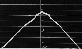
3.0 98/07/26 11:45:00 37.58N 118.90W 1.9 6 mi SE of MAMMOTH LAKES 4.0 98/07/26 11:37:45 37.58N 118.90W 2.0 6 mi SE of MAMMOTH LAKES
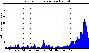
Does this look like a radiator about to blow?
|
|
.
..
"Being a scientist, I concur with the idea that science and art are bound together. Both are tools formed from the mind, both reveal truths that otherwise would remain obscure and unseen. At their purest forms, the science of art and the art of science are one, now and forever more. This website is now one of my favorites." Jason Latta |
.
VENTURE INTO THE VAULT OF WONDERS . .
PLEASE RETURN: THIS SITE CONSTANTLY CHANGES
OPTIONAL
MIDI
|
|---|
|
 .
.

