Subj: Frequencies of interest
Date: 2/11/02 3:10:12 AM Pacific Standard Time


A bit over my head, but it's info about frequencies at which GPS (GWEN) operates. Just thought I'd pass it along...

http://flattop.its.bldrdoc.gov/propdata/ 


U.S. Department of Commerce NTIA/ITS
Institute for Telecommunication Sciences
ITS Propagation Data Measurements


FTP    ftp://flattop.its.bldrdoc.gov/propdata/    access raw propagation measurements from FTP directories.


To install the Profile Plot Program (PFL_PLOT) for Windows-95/98/NT/2000:
Download PFL_PLOT.exe and install from your hard drive.

README.txt file describes installation procedures.

If the software does not run because of a missing DLL, get salflibc.dll and put it into your C:\WINDOWS\SYSTEM directory.

Send any questions/comments/problems to Greg Hand, Email: gh@its.bldrdoc.gov Phone:(303)497-3375
1965-67 data (old, huh):

ITS Propagation Data Measurements - Phase 2 Data

http://flattop.its.bldrdoc.gov/propdata/phase_2.html

FTP    ftp://flattop.its.bldrdoc.gov/propdata/phase_2/    access raw Phase 2 propagation measurements from FTP directories.

PHASE_2 data are spot measurements using frequencies that emphasize the UHF band (300-3000MHz) and environments that emphasize irregular terrain.

One feature is that many of the paths appear in pairs:
For each of the five measurement sets there are three data files:


Subj: Appleton GWEN coverage
Date: 2/11/02 3:10:14 AM Pacific Standard Time

Seen this? How's YOUR brain feeling? 

Figure 2. 300 kHz signal coverage prediction plot for the Appleton GWEN site,
showing contours for field strengths of 37.5, 50.0, 60.0, and 70.0 dBµV/m.
http://www.its.bldrdoc.gov/tpr/1999/its_t/aug_gps/aug_gps.html
 

APPLETON, WA

Status:                     Operational

RBn Antenna Location:       45° 46.53' N;121° 19.33' W

REFSTA Ant Location (A):    45° 46.95769' N;121° 19.65281' W

REFSTA Ant Location (B):    45° 46.95741' N;121° 19.63429' W

REFSTA RTCM SC-104 ID (A):  172

REFSTA RTCM SC-104 ID (B):  173

REFSTA FIRMWARE VERSION:    RD00-1C19

Broadcast Site ID:          871

Transmission Frequency:     300 KHZ

Transmission Rate:          100 BPS

Signal Strength:            75uV/m at 250 SM
DGPS Configuration for all sites
http://www.navcen.uscg.gov/dgps/DgpsCompleteConfiguration.htm

Subj: Info on conversion of GWEN to DGPS
Date: 2/11/02 3:10:15 AM Pacific Standard Time


DGPS
Status
Coverage Plot
References
Nationwide Expansion
SMEF Information
Report an Outage
FAQ
Other Sites

  Nationwide DGPS Status Report

The Nationwide Differential expansion is continuing to make progress. Funding for this year is about half of the administration's request. Single coverage expected in 2002 is now hoped for the year 2003. Last year, the Coast Guard’s Nationwide DGPS (NDGPS) implementation team was very busy refining the procedures for converting a GWEN (U.S. Air Force Ground Wave Emergency Network) site to an NDGPS site. To date, there are twelve sites that have been fully converted from their GWEN configurations to transmit DGPS corrections. These sites are located near Chico CA, Clark SD, Driver VA, Penobscot ME, Savannah GA, Macon GA, Whitney NE, Hudson Falls, NY, Billings MT, New Bern NC, Summerfield TX and Flagstaff AZ. The site at Appleton WA continues operation in its test configuration and the site near Hartsville TN increased its antenna to 299 feet.

As background, the Coast Guard is part of the seven-agency partnership for the Department of Transportation’s Nationwide Differential GPS expansion initiative to provide DGPS signals for public safety services. The Coast Guard brings its expertise in building, operating and maintaining DGPS sites to the partnership. The other members of the project include; U.S. Air Force, Federal Railroad Administration, U.S. Army Corps of Engineers, Federal Highway Administration, National Oceanic and Atmospheric Administration, and the Office of the Secretary of the DOT.

Major NDGPS projects for this year include:

  1. Completing the transfer of GWEN property leases, permits, and ownership to the Coast Guard. Of the 50 Air Force properties selected for NDGPS use, only five sites remain unresolved.
  2. Continuation of numerous engineering studies.
    In April the Hagerstown, MD site will serve as a test bed for a concept demonstration of an extremely high accurate differential system. This project is excepted to demonstrate the ability to provide users with carrier phase observables that will provide better than 20 centimeters vertical accuracy.
  3. Converting 7 GWEN sites to NDGPS beacons.
    For the latest planned construction:
    NDGPS Sites Planned for Construction CY2001
  4. Construction of two new sites, one near Brainerd, MN and the other near Myton, UT.
    • The Minnesota Department of Transportation has an ongoing effort to work with local representatives to identify a suitable site near Brainerd MN.
    • The Myton UT site was selected from several offered by the BLM. The FHWA is completing the environmental documents and the USCG is working with the BLM to finalize a site permit.

New site work near Hannibal OH, Greensboro NC, and future sites in Alaska are on hold pending funding availability.

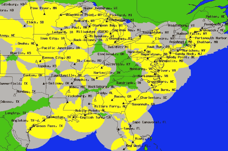
Many of you are interested in what sites are going to be installed and when. Currently, the Coast Guard plans to operate 12 additional sites by the end of this year. Some of these sites are already in progress and the remaining ones were selected to provide coast-to-coast corridors for the Program Sponsor, the Federal Railroad Administration. Of course all of the standard caveats apply – no unforeseen delays or contracting issues, subject to funding availability, established communications and of course the weather is always an unknown.

NDGPS Sites Planned for Construction CY2001

All Nationwide DGPS Sites -
Operational, Planned, & Proposed


Subj: GWEN in an area near YOU!
Date: 2/11/02 3:10:15 AM Pacific Standard Time

Pertinent stuff about GWEN

According to NAVCEN, sites appear to operate in the 300 kHz range (VHF). 

DGPS Configuration for all sites
http://www.navcen.uscg.gov/dgps/DgpsCompleteConfiguration.htm

DETROIT, MI
Status:                     Operational
RBn Antenna Location:       42° 17.8' N;83° 5.7' W
REFSTA Ant Location (A):    42° 17.84042' N;83° 5.7175' W
REFSTA Ant Location (B): 42° 17.83364' N;83° 5.73171' W
REFSTA RTCM SC-104 ID (A):  116
REFSTA RTCM SC-104 ID (B):  117
REFSTA FIRMWARE VERSION:    RD00-1C19
Broadcast Site ID:          838
Transmission Frequency:    
319 KHZ
Transmission Rate:          200 BPS
Signal Strength:            100uV/m at 100 SM
HOWEVER...... according to this article at....

http://www.rense.com/ufo5/gwen.htm

The Ground-Wave
Emergency Network
(GWEN) System
By Dr. Byron Weeks <btw777@if.rmci.net>
11-28-99

The Ground-Wave Emergency Network (GWEN) is a communications system that the military is in the process of constructing as we speak. It operates in the very-low-frequency (VLF) range, with transmissions between 150 and 175 kHz. This range was selected because its signals travel by means of waves that have a tendency to hug the ground rather than by radiating into the atmosphere.

...Weeks is saying they operate in the VLF range. Don't know which is true — VHF or VLF. Also need to research more about effects of different ranges on humans. Have some articles; will review.
This East Coast plot and other coverage plots at:
http://www.navcen.uscg.gov/dgps/coverage/Default.htm

Radiowave frequency ranges
spaceweb@oulu.fi - last update: 24 November 1998, 1335 UT

Radiowave Frequency Ranges
Abbr. Name Frequencies
ELF Extremely Low Frequencies 30 - 300 Hz
VF Voice Frequencies 0.3 - 3 kHz
VLF Very Low Frequencies 3 - 30 kHz
LF Low Frequencies 30 - 300 kHz
MF Medium Frequencies 0.3 - 3 MHz
HF High Frequencies 3 - 30 MHz
VHF Very High Frequencies 30 - 300 MHz
UHF Ultra High Frequencies 0.3 - 3 GHz
SHF Super High Frequencies 3 - 30 GHz
EHF Extremely High Freqiencies 30 - 300 GHz

The International Telecommunication Union (ITU) has defined the radiowave frequency ranges as shown in the table. Note that most of the plasma waves occurring in the magnetosphere are "ultra-low-frequency" (ULF) range geomagnetic pulsations occurring below 5 Hz, i.e., outside of this classification. Their high frequency limit corresponds to magnetospheric ion gyrofrequencies (which are low because of small B and high m).

On the other hand, wave types relating to electrons, or those created at the ionospheric altitudes, can reach frequencies covered by the table (ELF - VLF). Instruments like incoherent radars work typically at VHF and UHF frequencies.

See also:

http://www.oulu.fi/~spaceweb/textbook/radiof.html

Subj: NEUROLOGICAL EFFECTS OF RFR; environmental coverage; epidemiology
Date: 2/11/02 4:19:59 AM Pacific Standard Time

Isn't this more than you ever wanted to know? I think we need GWEN like another hole in the head (or maybe it's already done that).

Seminal paper on the subject:
http://www.wave-guide.org/library/lai.html
NEUROLOGICAL EFFECTS OF RADIOFREQUENCY ELECTROMAGNETIC RADIATION

Bioelectromagnetics Research
Laboratory, Department of Bioengineering, School of Medicine and College of Engineering, University of Washington, Seattle, Washington, USA

Paper presented to the Workshop on possible biological and health effects of RF electromagnetic fields.

Mobile Phones and Health, Symposium, October 25-28, 1998, University of Vienna, Austria.

Reproduced with permission of Henry Lai

INTRODUCTION

Radiofrequency electromagnetic radiation (RFR), a form of energy between 10 KHz-300 GHz in the electromagnetic spectrum, is used in wireless communication and emitted from antennae of mobile telephones (handys) and from cellular masts. RFR can penetrate into organic tissues and be absorbed and converted into heat. One familiar application of this energy is the microwave ovens used in cooking.

The close proximity of a mobile telephone antenna to the user's head leads to the deposition of a relatively large amount of radiofrequency energy in the head. The relatively fixed position of the antenna to the head causes a repeated irradiation of a more or less fixed amount of body tissue. Exposure to RFR from mobile telephones is of a short-term, repeated nature at a relatively high intensity, whereas exposure to RFR emitted from cell masts is of long duration but at a very low intensity. The biological and health consequences of these exposure conditions need further understanding.

Formal research on the biological effects of RFR began more than 30 years ago. In my opinion, the research has been of high quality, innovative, and intelligent. All of us who work in this field should be proud of it. However, knowledge of the possible health effects of RFR is still inadequate and inconclusive. I think the main barrier in understanding the biological effects of RFR is caused by the complex interaction of the different exposure parameters in causing an effect. An independent variable of such complexity is unprecedented in any other field of biological research.

In this paper, I have briefly summarized the results of experiments carried out in our laboratory on the effects of RFR exposure on the nervous system of the rat. But, before that, I will discuss and point out some of the general features and concerns in the study of the biological effects of RFR.

....more
and this is just radio & TV
http://www.ortho.lsumc.edu/Faculty/Marino/EL/EL10/Levels.html
Levels in the Environment

The artificial EMF environment of the U.S. is a superimposition of contributions from many sources having diverse operating characteristics. They include high- and low-power emitters that can be omnidirectional or directional, and that can operate continuously or intermittently. At high frequencies, the general EMF background consists predominantly of the AM radio band (0.535-1.604 MHz) and the FM and TV band (54-806 MHz). About half the U.S. population is exposed to these sources at levels above 0.005 µW/cm2 at any given moment, and about I% is exposed above 1 µW/cm2 (Fig. 10.1)(1). The actual number of people exposed above 1 µW/cm2 in any given day, week, or month is considerably greater because of population mobility.


http://www.ortho.lsumc.edu/Faculty/Marino/EL/EL10/Epidem.html
Epidemiological Studies and Surveys

Environmental studies. Suicide is a stress-related phenomenon that may be viewed as a specific manifestation of depressive mental illness. We studied the relationship between suicide and power-frequency field strength (2, 14). We were concerned with how the field strength at the residences of suicides compared with that at appropriately-chosen control addresses. The study group consisted of the 598 suicides that occurred within the study area (in the Midlands of England) during a 7-year period and an equal number of controls. We first examined the relationship between suicide and the computed electric and magnetic fields of nearby high-voltage power lines. We found a statistically significant correlation between both fields and the occurrence of suicide, but we could not determine whether more or less than the expected number of suicides occurred at locations of high field strengths (14). Since the total power-frequency field at any site is due to contributions from many sources- high-voltage lines, low-voltage lines, household wiring and appliances- we then proceeded with a study of measured field strengths. The mean measured magnetic field strength for the suicide group (867 µgauss), was found to be significantly higher than that of the control group (709 µgauss) (2). The proportion of suicide addresses in the high-field-strength region was 40% greater than the proportion of control addresses (Table 10.6).

.........and by golly, this stuff can sterilize ya!

Date: 2/11/02 6:33:41 AM Pacific Standard Time

Looky here! Kansas and Texas both ringing/beaming.

It just dawned on me: these things are RELAY STATIONS. As in Bearden's Woodpecker GRID?