1/24/2006 11:02:38 A.M. Pacific Standard Time

Hi Kent,

 
STA orig link
http://www.surfingtheapocalypse.net/cgi-bin/forum.cgi?read=123398
 
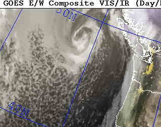
Check out the chemtrails in the approaching weather system, left side of
sat photo.
 
http://www.nrlmry.navy.mil/sat-bin/display10.cgi?SIZE=full&PHOT=yes&AREA=pacific/eastern/wash_oregon&PROD=vis&TYPE=ssmi&NAV=epac_westcoast&DISPLAY=Latest&ARCHIVE=Latest&CGI=epac_westcoast.cgi&CURRENT=20060124.1800.goes10.vis.x.wash_oregon.x.jpg&MOSAIC_SCALE=15
 
Also shows here :
http://www.nrlmry.navy.mil/sat-bin/display10.cgi?SIZE=full&PHOT=yes&AREA=pacific/eastern/pac_northwest&PROD=vis&TYPE=ssmi&NAV=epac_westcoast&DISPLAY=Latest&ARCHIVE=Latest&CGI=epac_westcoast.cgi&CURRENT=20060124.1800.goes10.vis.x.pac_northwest.x.jpg&MOSAIC_SCALE=15
 
Same here, not as pronounced
http://www.nrlmry.navy.mil/sat-bin/display10.cgi?SIZE=full&PHOT=yes&AREA=pacific/eastern/north_calif&PROD=vis&TYPE=ssmi&NAV=epac_westcoast&DISPLAY=Latest&ARCHIVE=Latest&CGI=epac_westcoast.cgi&CURRENT=20060124.1800.goes10.vis.x.north_calif.x.jpg&MOSAIC_SCALE=15
 
but look here between 20 - 30 N and 130 -140 E
 
http://www.nrlmry.navy.mil/sat-bin/display10.cgi?SIZE=full&PHOT=yes&AREA=pacific/eastern/pac_northwest&PROD=vis&TYPE=ssmi&NAV=epac_westcoast&DISPLAY=Latest&ARCHIVE=Latest&CGI=epac_westcoast.cgi&CURRENT=20060124.1800.goes10.vis.x.pac_northwest.x.jpg&MOSAIC_SCALE=15
 
And, compare the VIS with the IR of the VIS above
 
http://www.nrlmry.navy.mil/sat-bin/display10.cgi?SIZE=full&PHOT=yes&AREA=pacific/eastern/pac_southwest&PROD=ir&TYPE=ssmi&NAV=epac_westcoast&DISPLAY=Latest&ARCHIVE=Latest&CGI=epac_westcoast.cgi&CURRENT=20060124.1800.goes10.ir.x.pac_southwest.x.jpg&MOSAIC_SCALE=15

Yeah, they are just 'contrails', cause somebody's trying to 'con' us.....

So anaylsis shows these trails to be cold relative to the surrounding air, because they are very white. Warm shows up as grey-->black.