RETURN: THE LAB
Hall of Records |
|
.
...
RETURN: THE LAB
Hall of Records |
|
.
..
10/25/99 Is Los Angeles on HIGH ALERT
3.7 99/10/25 11:24:45 34.53N 116.29W 3.9 27 mi N of JOSHUA TREE
3.1 99/10/25 10:17:58 34.63N 116.31W 0.0 34 mi N of JOSHUA TREE [Notice Depth, 00]
4.6 99/10/25 11:26:00 34.62N 116.24W 0.0 33 mi N of JOSHUA TREE
radar
NOT ON USGS:
Monday, October 25, 1999 Published at 22:57 GMT 23:57 UK
![]()
![]() UK: Wales Scientists investigate earth tremor
UK: Wales Scientists investigate earth tremor
An earthquake struck mid Wales on Monday night, prompting dozens of people to telephone the emergency services.
![]() British nuclear arms plant close to disaster Sunday October 24, 1999 also
see:
British nuclear arms plant close to disaster Sunday October 24, 1999 also
see:
![]()
Also See New Zealand Quake: Mag 6.3: http://www.gphs.vuw.ac.nz/seismology/igns_report.html
Becomes on USGS Mag 5.6: http://wwwneic.cr.usgs.gov/neis/bulletin/bulletin.html
EMAIL, [Aus] 10/25/99 11:44:36 PM Pacific Daylight Time: EARTHQUAKES: Something is a little awry with USGS lately. We never did get notification from USGS about the 7.1 or 7.3 Mg quake at Joshua Tree, CA. IDC didn't pick it up for the longest while and finally we quit checking their site.
This morning, early, we received a phone call from Peter Caffell in Auckland, NZ and email from Matt Stinson in Christchurch who shared that the Lake Taupo area is getting some pretty impressive shakes. According to USGS, this morning a 5.6 quake hit 5km WNW of Lake Taupo. However, IGNS (Institute of Geological Nuclear Sciences) who is New Zealand's equivalent of USGS, pegged the quake at 6.3. It was relatively deep at 164km which means there is some interesting plate shifting going on. It was felt widely throughout the North Island and as far south as Christchurch. It also rattled Hastings where there was another 4.3 quake there yesterday.
At the time, we found seismologists were terribly under equipped to adequately monitor volcanic activity and their warning system then consisted of paging, faxing and a siren. Not nearly enough notification for the potential dangers of the area. Currently White Island and Mount Ruapehu are on Level 1 Alerts. We will continue to watch this area very carefully.
EMAIL, 10/26/99 9:10:20 AM Pacific Daylight Time: Even more odd than having a lower magnitude, the New Zealand quake does not show up at all on the map: http://www.iris.washington.edu/seismic/60_2040_1_4.html
 |
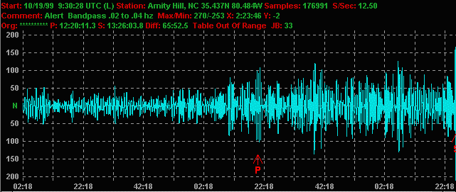
INTERNET MESSAGE ALERT: Big Quake, just got verification, 7.0+ Mojave Desert Right on the major Mojave faults. Quake 2:46-2:48 PST SEISMOGRAPH |
5.0 99/10/16 10:38:48 34.44N 116.24W 0.1 21 mi N of JOSHUA TREE
5.8 99/10/16 05:57:21 34.44N 116.25W 1.0 21 mi N of JOSHUA TREE
5.3 99/10/16 02:51:52 34.41N 116.56W 6.2 22 mi NNW of YUCCA VALLEY
7.0 99/10/16 02:46:44 34.60N 116.27W 6.0 32 mi N of JOSHUA TREE
![]()
Major power failure at Edwards Airforce Base, that's what they're saying right now (3:53ish California time). 20-car Amtrack derailment. Fires in Barstow. Problems in San Pedro. Art Bell felt it in Nevada area. 2:46am 7.0 quake.
![]() MESSAGE BOARDS
MESSAGE BOARDS
![]() SEISMOGRAM
SEISMOGRAM
![]() MORE DETAILS
MORE DETAILS
 |
|
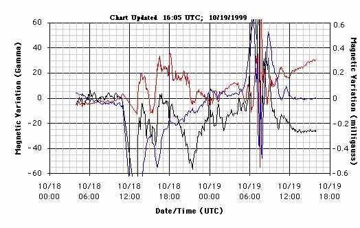
The Daily Vector Analysis for Geomagnetic Field Changes (c)1999 Geo-Seismic-labs
Hello All:
An update is in order here...
I have the preliminary Geomagnetic Field analysis of the Hector, CA M7.0 Earthquake on my Website in the archives section right now.
http://www.geo-seismic-labs.org/GSL/OCT99/16th/991016094644ZEQ1.GIF
http://www.geo-seismic-labs.org/GSL/OCT99/16th/991016094644ZEQ2.GIF
http://www.geo-seismic-labs.org/GSL/OCT99/16th/991016094644ZFFT.GIF
I stopped recording events long enough to get these up on the web ASAP.
Doing that is going to make a 24 hour daily graph including the major earthquake on it almost impossible! So, consider this as my preliminary data analysis.
The next release will include all of the aftershocks including the Daily Delta Reading this evening...
Looks like this one is going to need an entire Web page to itself, or more!
http://www.geo-seismic-labs.org/
In Co-operation with Charlie Plyler at Elfrad: http://www.elfrad.com
Wow Frank, Just back from Canada and this happens. Looks like I have some homework waiting for me.
Sending a precursor shot from Elfrad. The ULF signal reached an alert level 120 minutes prior and rose to full alarm status 90 minutes before the Southern Cal quake. During the past 2 months strong precursors have been recorded before each major event.
Congrats on the forecasting, looks like you hit it on the head.
EMAIL, 10/16/99 10:41:51 AM Pacific Daylight Time: KNX radio Los Angeles pointed out the Hector Mine quake was centered inside the restricted Twenty-Nine Palms Marine Corps Training Center. It is a large base and has two big craters (volcanic I think) on the edges of the base. KNX said the base is letting geologists on base to study the quake. It was a very effective way to jangle the nerves of six million people in nearby L.A., say if one were trying to build worldwide hyper-anxiety leading up to . . . millennium madness.
![]() BULLETIN BOARD, Saturday, 16 October 1999, at 5:08
a.m.: About two hours ago, I woke up right before an earthquake
at about 2:45 a.m. PDT in Orange County, California. While the shaking was
subsiding, there was this HUGE flash of blue light from the sky, right above
my place. There's quite the cloud coverage, so I couldn't tell where it was
coming from, other than within the coverage--and it seemed to light up the
entire sky with the flash. It lasted longer than a *flash,* though. What
was also odd was that I heard this very loud, low-pitch, mechanical
sound.
BULLETIN BOARD, Saturday, 16 October 1999, at 5:08
a.m.: About two hours ago, I woke up right before an earthquake
at about 2:45 a.m. PDT in Orange County, California. While the shaking was
subsiding, there was this HUGE flash of blue light from the sky, right above
my place. There's quite the cloud coverage, so I couldn't tell where it was
coming from, other than within the coverage--and it seemed to light up the
entire sky with the flash. It lasted longer than a *flash,* though. What
was also odd was that I heard this very loud, low-pitch, mechanical
sound.
Hard to describe, except that it sounded like it was revolving--louder at one point than another. Then, almost immediately, I saw the same light (almost a burst of light with that loud sound) about halfway between my place and the horizon over a large, vacant field behind where I live. And then on the horizon--when it flashed, it lit up half the horizon (like you've see with those atom bomb explosions, but without the *mushroom*). Then, one more flash, but this time it had moved about 1/4 mile south toward the beach. Then, I heard that mechanical sound again, only from a greater distance--and simultaneously felt a small aftershock.
I've experienced transformer blow-outs before too--with a blue light and almost blue lightening/static in the sky--but this happened over an empty field, without any electrical or phone wires there. And it was very different.
About 10 minutes after the last flash, there was a helicopter flying over the field and headed toward the Santa Ana river, with its search lights on. In about another 10 minutes, I heard loud voices off in the distance, as if they were transmitted over a police radio. So, this must have been reported to the local authorities and they're investigating something...
My electricity never went out, but obviously there was some type of power surge, because my computer had turned itself off.
Am I crazy? Did anyone else in the area of Costa Mesa/Newport Beach see these lights and/or hear that sound?
EMAIL, 10/18/99 8:45:11 PM Pacific Daylight Time: I'm near Redding,CA.. On Oct 9th while camping near Wildwood, CA in Trinity County we saw a huge ball of light. It wasn't a meteor. It traveled slow but faster then jet aircraft. It went from SW to NE and disappeared behind a mountain. This was between 7:45 and 8:05 PM. We went to bed at 8:15 and that is when I checked the clock. After we saw it we watched for a short time more to see if we might see another. Also saw another ball of light on the 16th in the eastern sky. Traveling N to S. This was in early evening shortly after dark. I didn't check the time. We were evacuating our daughters home because of the fire. If you put your fist out these lights were larger then a fist. Did anyone else see these?
EMAIL, 10/20/99 11:43:33 AM Pacific Daylight Time: Greetings from San Franciscol Your site is amazing and I check it every day. I saw the light mentioned on your current opening page. On Saturday evening, October 16, between 7:00 and 7:15, I was out on my balcony enjoying the beautiful and unusually warm evening. I saw a jiggly line of whitish-yellown light going straight down towards the ground. It disappeared just above the horizon but did not reach it. I was looking in a North-east direction from Chinatown. Holding my arm straight out, it was 1/2 the size of my thumb. I saw this long line of light for 3 secs. (Could it have been connected fire dousing or a meteorite?)
![]()
QUAKE LAB
EDITOR'S NOTE, 10/23/99: The below data and correspondences are admittedly disjointed due to a realtime stream of information incoming. Later I'll try to sort it all out. Presently think of this as workshop theory.
 |
ELFRAD
ALERT & ORBIT EXPERIMENTAL
GLOBAL MAPS WATCH
System just went into alert status. Sending graph. Could be false alarm but it appears an event is imminent. The time is 13:35 Hrs UTC or 09:35 EST. Please check your data for precursor info. [Posted by ORBIT 10/19/99 7:05 PST, suggest an experimental all data watch including seismogram, Red Puma watch, Cal-Nev, solar, radar, other] |
![]() PROBABLE EVENT:
99/10/19
13:36:48 9.49S 158.17E 33.0 5.4Mb B SOLOMON ISLANDS
PROBABLE EVENT:
99/10/19
13:36:48 9.49S 158.17E 33.0 5.4Mb B SOLOMON ISLANDS
SECONDARY EVENT: 19Oct1999 18:18:43.6 45.0N 43.0E 33 MS=4.1 M GSR UKRAINE-MOLDOVA-SW RUSSIA 1933
ONGOING WATCH INCLUDES: INDIANA RING HAARP GUAGUA PICHINCHA VOLCANO
![]() ONGOING Another
hurricane-includes US Virgin Islands, Puerto Rico areas
ONGOING Another
hurricane-includes US Virgin Islands, Puerto Rico areas
![]()
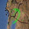
Unusual ongoing red-strike artifact on radar


ADDITIONALLY
10/19/99 -- 11:45 AM: CATANIA, Sicily (AP) - Experts were monitoring Mount Etna for a possible eruption Tuesday, a day after the volcano gushed lava and spewed smoke.
![]() MESSAGE BOARD, 12:58:02 PM 10/19/99:
The push from the Pacific Plate caused the recent 7 magnitude in Southern
CA. It has further forced energy and pressure eastward and onto the New Madrid
Fault. The buildup of pressure on the New Madrid Fault is now near it's maximum
capacity.
MESSAGE BOARD, 12:58:02 PM 10/19/99:
The push from the Pacific Plate caused the recent 7 magnitude in Southern
CA. It has further forced energy and pressure eastward and onto the New Madrid
Fault. The buildup of pressure on the New Madrid Fault is now near it's maximum
capacity.
EMAIL, 10/19/99 5:14:06 PM Pacific Daylight Time: We felt one aftershock in the M4.8 range about an hour before your alarm going off. However, there certainly could be a much larger event on the horizon. I've been connecting with local folks and have interviewed a few for their reaction and to see what it is that they expect is next. Most of them are saying it isn't over yet. One of them was even gifted with the foresight to know that the M7.0 was coming and when it did, He thought for sure that it was Los Angeles again! We all got off easy this time, with a M7.1 in the middle of a Desert. The next one, or an aftershock of the M7.1 closer to the population centers could be just as bad as a "Big One" on the San Andreas. I'll check the data for any correlation and get back to you soon. FrankCondon@Geo-Seismic-Labs.org
UPDATE, 10/20/99 1:42:08 AM: I took a look at the time period specified and I think that we have a match!
http://www.geo-seismic-labs.org/GSL/OCT99/19th/991019133648ZEQ1.GIF
Regards, Frank Condon http://www.geo-seismic-labs.org/
![]()
Re: Bright Lights in California
Duhhh, KAHBOOM: Researchers Testing Calif. Faults Oct. 20, 1999; 7:45 a.m. EDT
A series of 93 small underground detonations, beginning today and continuing through Sunday, is being conducted as sort of an ultrasound procedure, aimed at giving scientists a better look at the region's fault lines.
Researchers said the timing of the tests, beginning days after Saturday's Hector quake in the Mojave Desert, was a coincidence. continue
EMAIL, 10/24/99 9:50:08 AM Pacific Daylight Time: I don't see any mention of the "coincidence" that the day before the biggie there were 3 moderate quakes at ZERO depth (often an indication of blast) at the location of the biggie. In the 6 or 7 days before the quake (all that was listed on the "recent" list) there were no other Joshua Tree quakes.. not even teentsy ones. Which suggests that it wasn't a site of continuous rummbles like Mammoth (though I would have to go back to older lists to check that).
So... its pretty coincidental that
1. prior to the quake there was at least a week of NO quakes until a series of 3 quakes (about 20 minutes apart if I remember right) at ZERO depth.
2. right after the big quake, with tons of media coverage, there was NO information from military types even though the quake was on military property.
3. after the fact the gov't admits to blasts but says they started AFTER the big quake. Yeah, right!
ARCHIVES: During the devastating PNP tsunami and ongoing a team from the National Science Foundation has been drilling test holes in the fault lines, 180: Woodlark Basin Project. Also see
EDITOR'S NOTE: Feeling feisty today, is it me, or does it look like science has become a bunch o' Bluebeards blowin stuff up to see what happens, huh, HUH? Either that or they shrink reality down to a lil ol wee slit so the data-bytes come blippin through one at a time so's not to scare em. Either way, do we leave reality solely up to science? Nawwwww, get ready, get set, behold:
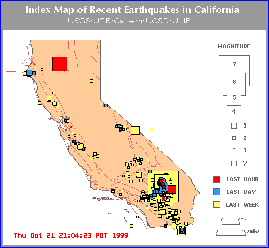
5.0 99/10/20 18:57:38 34.86N 116.39W 4.4 33 mi SSW of BAKER
5.0 99/10/20 18:54:35 34.80N 116.41W 1.7 37 mi SSW of BAKER
4.5 99/10/20 18:54:06 34.87N 116.40W 4.2 33 mi SW of BAKER
4.1 99/10/21 18:58:43 34.57N 116.26W 6.0 30 mi N of JOSHUA TREE
99/10/22 02:18:58 23.50N 120.53E 33.0 5.6Ms B TAIWAN
99/10/22 03:10:18 23.45N 120.53E 33.0 5.3Ms B TAIWAN
99/10/22 13:43:14 34.85N 116.41W 5.0 3.9Ml <PAS> SOUTHERN CALIFORNIA
99/10/22 16:08:48 34.86N 116.41W 0.6 5.0Ml <PAS> SOUTHERN CALIFORNIA
99/10/22 16:51:36 34.82N 116.39W 4.1 3.8Ml <PAS> SOUTHERN CALIFORNIA
99/10/22 17:51:15 38.08N 112.73W 5.0 4.2Ml <SLC> UTAH
| DID ANYONE IN LAS VEGAS OR CAL SEE AN LA QUAKE-ALERT COME UP ON CABLE 10/22/99 AROUND NOON PST? EMAIL KENT |
| MISSING QUAKE OVER SHASTA: DID ANYONE SEE
A 5.0 QUAKE OVER SHASTA. PLEASE SEND GRAPHIC IF YOU HAVE
EMAIL, 10/22/99 7:59:13 PM Pacific Daylight Time: I was hoping your quake animation would have picked up the large red square (estimated 5.4 to 5.9 mag event) on the CA/NV map dead center over Mt. Shasta last night. It showed up on the large map but when you zoomed in, it wasn't there and there were no details about. I think it was about 9PM or so PT when I viewed the map. It had disappeared off the map by this morning. REPLY TO SHASTA MAP QUERY, 10/23/99 7:34:52 AM Pacific Daylight Time: I captured the image and then checked local seismographs to check the waveform and could not find and sign of an event anywhere close.
Earthquake safety information and links
|
EDITOR'S NOTE: never seen it so dangerous quake window, magstorm, aftershocks, fools blasting on faultline.
MESSAGE BOARD, 11:08:12 AM 10/21/99: Last night at 10:21 I was laying in my bed listening to KSFO radio,and snuggling with my parrot. When out of the corner of my eye I saw a blue light flash across the sky from NE to SW. What was so unusual about this was it was so BIG, bright, and blue and long. Simular to a shooting star...except this seemed like it was closer and where a shooting star would make a line across the sky about the size of a pencil line, this was over a 1/8 of a inch! And BRIGHT,BRIGHT blue. It freaked my bird out too, she grabbed my nose and then crashed into the dresser. Anyone else see it? Or have any idea what the heck it was?
MESSAGE BOARD, 02:39:46 PM 10/21/9: Looks like we are almost neighbors..:) I'm at 280/Bascom And what I saw came from the direction of Downtown SJ area to Santa Cruz, or toward your house. I'm not quite sure if these things come back but i'll be looking again tonight. It was quite a site to see. Man...it was big!
EMAIL, 10/21/99 5:17:01 AM Pacific Daylight Time: As promised: Looks like the New Madrid embayment has started to wake up:
99/10/13 15:58:59 35.69N 90.27W 8.6 2.4 B 21.9 km east of Trumann, AR (C)
99/10/20 09:00:03 34.77N 91.30W 11.3 2.5 D 10 km (6.2 mi) east of Clarendon AR (C)
99/10/21 08:18:00 36.49N 91.02W 19.3 3.9Lg C 6 km north of Pocahontas, AR (C)
99/10/21 08:49:49 36.51N 91.05W 11.7 2.7 D 9 km north of Pocahontas, AR (C)
SEE DATA: Flash Rusty WASHINGTON DC PULSE Helicorder
![]() Big Earthquakes, Predictions and the New
Millennium
Big Earthquakes, Predictions and the New
Millennium
A commentary by Susan Hough, USGS Pasadena
10/01/99 "Moreover, if another event were to happen, there is no reason to think it might happen in California. In fact, the most likely location for a future large event might be, curiously enough, close to one of the three events that have already happened. This counterintuitive possibility arises from stress interaction theories that seismologists have developed in recent years. The idea is that an earthquake affects the surrounding crust in such a way as to "push" neighboring faults towards failure. It's a little like moving one boxcar on a train while the others stay fixed--the push will be transmitted along the line, most strongly to the immediately adjacent cars."
![]()
![]() PANTHER ACROSS THE SKY
PANTHER ACROSS THE SKY

Tecumseh and the New Madrid Earthquake
This was the earthquake which occurred where no tremor had ever been recorded before; where there was no scientific explanation for such a thing happening; where no one cold possibly have anticipated or predicted that an earthquake could happen. No one except Tecumseh.
![]()
.
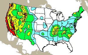
![]() 10/22/99 SEVERE MAGSTORM
10/22/99 SEVERE MAGSTORM
![]() 10/25/99 M-CLASS FLARE
10/25/99 M-CLASS FLARE
![]() 10/25/99
M-CLASS FLARES (2)
10/25/99
M-CLASS FLARES (2)
The geomagnetic field is expected to be active to very severe storm (Kp=8) on October 22. A coronal stream will cause the geomagnetic field to reach unsettled to minor storm levels from late on October 24 to October 26. Low frequency (below 2 MHz) radio wave propagation along east-west paths over high and upper middle latitudes is generally useless.
WHEN THE MAGNETIC FIELD DROPS: TIME TO DREAM

![]() Xray
Flux
Xray
Flux
![]() Proton
Flux
.
Proton
Flux
.![]() Electron
Flux..
Electron
Flux..![]() Magnetometer
.
Magnetometer
.![]() Kp Index
Kp Index
![]() Aurora:
image one,
image two,
image three
Aurora:
image one,
image two,
image three
![]() Aurora Alert (passed)
Aurora Alert (passed)
For the past several months, the Sun has been quite active; but fortunately, due to the heliocentric aspects, the solar flares and ejection’s have been aimed in other directions. That will not be the case by the end of this month. As you know, we are approaching the Sun spot solar maximum, which this time occurs while the Sun is already acting very strangely (unstable), continue
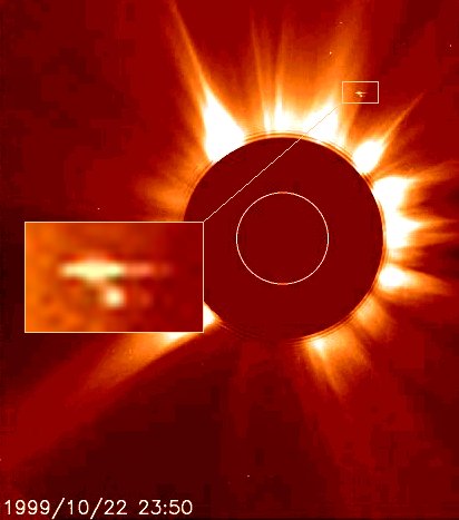
EMAIL, 10/23/99 9:08:56 AM Pacific Daylight Time: Kento, I checked the time frame that this was taken from and there are no planets that are supposed to appear in this time frame. Tell me what you think. Is this the same Sun Cruiser we have seen time and again?
![]()
![]()
![]()
![]()
![]()
![]() SOHO ANOMALIES
SOHO ANOMALIES
![]()
![]()
![]()
![]()
![]()
![]()
![]()
![]()
![]()
![]()
![]()
![]()
![]()
Updated 7:29 AM ET October 19, 1999
ORTING) -- "Discovery Magazine" is calling Mount Rainier the most dangerous volcano in North America. The science magazine says that several hundred-thousand residents have encroached on the 14-thousand-410-foot peak's ancient mud flows. The town of Orting would apparently be the first to be leveled by a speeding wall of mud if Rainier blows its top again. That means that 100-thousand people would be directly in harm's way if the volcano erupts. "Discovery" says that could happen any time.
![]()
Large Blob Discovered Deep in the Earth
![]()
![]()
Kind of slim in October. Any coins tossed in the hat, much needed.
![]()
![]()
![]() 1999:
the year that seismic shifts killed 20,000 across the world
1999:
the year that seismic shifts killed 20,000 across the world
FROM Colombia to India, Turkey to Taiwan, Mexico, and now California, 1999 has been the year of the earthquake. More than 20,000 people have died in six serious earthquakes this year, with many thousands more left injured and homeless.
![]()
.Data Base of Terrestrial Impact Structures
![]()
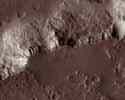
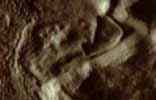
MARS
|
|
![]() RIVER LEAH
RIVER LEAH
![]() MARS, INCA CITY 3D
MARS, INCA CITY 3D
![]() Lake Steadman
and other things in its vicinity
Lake Steadman
and other things in its vicinity
![]() ISLAND
CITY, MARS
ISLAND
CITY, MARS
![]() ELAINE LUCAS
ELAINE LUCAS
![]() Possible Rootless Cones or Pseudocraters on Mars
Possible Rootless Cones or Pseudocraters on Mars
SLEUTHS: On July 4, 1998 Japan launched their PLANET-B Nozomi (means hope) to Mars. It was supposed to arrive in Mars orbit earlier this month, and send back pictures. Here is the original Reuters story:
Japan Probe Heads For Mars With All Systems Go http://www.ufoseek.org/News/Japmars2.htm
Japan's official Planet B website (still online, but seems to have been abandoned) http://www.planet-b.isas.ac.jp/index-e.html
There have been no updates there since Dec. 25, 1998!!
I don't recall hearing any subsequent announcements about the mission, good or bad. Maybe I missed something. What happened to it? It seems a bit strange nothing has been said about this mission for well over a year. I have sent an e-mail inquiry from their website ( yyoshida@stp.isas.ac.jp ) Anyone who has information about this please contact Ufoseek@aol.com
REPLY TO JAPANESE PROBE QUERY: When the probe escaped from the Earth's atmosphere, there was a trouble on the pressure-valve. Due to the accident, the probe lacked enough (driving) force to escape the atomosphere. To correct the problem, unexpected amount of the fuel was consumed. To complete the original mission of the probe, they changed their plan and adopted two more swing-by in order to save the fuel. continue
![]()
![]() Moon not quite dead
Moon not quite dead
![]()
![]() PUEBLO
BONITO
PUEBLO
BONITO
![]()
![]()
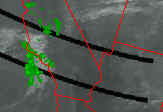
![]() WEIRD
WEIRD RADAR
RADAR![]()
AREA 51 KENTUCKY NORTH CAROLINA ALABAMA
![]() What's Going
on in our Skies?
What's Going
on in our Skies?
![]() Open
Forum Talk Radio - Chuck West, Host
Open
Forum Talk Radio - Chuck West, Host
![]() REMOTE
MIND CONTROL WEAPONS
REMOTE
MIND CONTROL WEAPONS
![]()
![]() UNITED STATES NAVY
TESTING OF LOW FREQUENCY ACTIVE SONAR ON HUMPBACK WHALES AND OTHER
BEINGS OFF THE ISLAND OF HAWAII
UNITED STATES NAVY
TESTING OF LOW FREQUENCY ACTIVE SONAR ON HUMPBACK WHALES AND OTHER
BEINGS OFF THE ISLAND OF HAWAII
![]()
![]()
10/22/99 9:53:05 AM Pacific Daylight Time: KS, as always you are tracking well. Perhaps things have changed and what was once stable has become unstable. How bout that radioactive leak on the flatbed truck from Tenn. to Hanford last nite , sheesh ! Another odd leak, authorities say it poses only a minimal risk to the public. Sure as hell has been some mad scrambling for only a "minor" leak. Lies again methinks. Same with downplaying the Taiwan quake of last night. You are track'in on something here.Ya got'em sweat'in lad and the damn Puget Sound area is rife with "bad ones" (drones), so in the terms of the mountain men of the past "watch yer topknot"
![]()
On 23 April 1994, around a hundred amateur astronomers reported seeing a possible darkening of the Moon, lasting 40 minutes, near the edge of the bright lunar crater Aristarchus. At the same time, the US Department of Defense's Clementine satellite was mapping the lunar surface.
![]()
![]() Ancient Buried City Near Dallas
Ancient Buried City Near Dallas
![]()
![]()
HAIL TO THE SEEKER: PROCEED |
|
